
AFRICA: For scanning the sea ice around Antarctica, the Scientists have used two submersible robots and the four-year survey’s results appears like good news for those concerned about the global climate. “Our surveys show that the floes are much thicker and more bent than reported by most drilling and ship-based measurements of Antarctic sea ice,” the team reported in the journal Nature Geosciences.
“We suggest that thick ice in the near-coastal and interior pack may be under-represented in existing in situ assessments of Antarctic sea ice and hence, on average, Antarctic sea ice may be thicker than previously thought.”
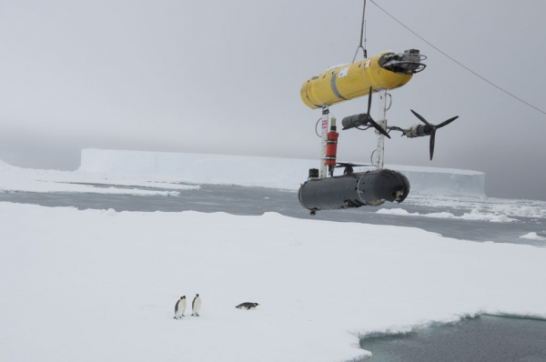
The Autonomous Underwater Vehicle (AUV), dubbed SeaBED, has spent the last four years surveying 500,000 square meters of ice thicknesses in the Weddell, Bellingshausen and Wilkes Land sections of Antarctica for British, US and Australian scientists.
The twin-hulled sub’s design means the vessel stays nicely stable for photographic work, and to allow the sonar to be aimed correctly and return consistent data. SeaBED runs on a 1.2GHz Pentium processor (hopefully without floating point issues) and uses Ubuntu Linux 8.04.
“Putting an AUV together to map the underside of sea ice is challenging from a software, navigation and acoustic communications standpoint,” said Hanumant Singh, an engineerat the Woods Hole Oceanographic Institution (WHOI) who built the AUV.
“SeaBED’s maneuverability and stability made it ideal for this application where we were doing detailed floe-scale mapping and deploying, as well as recovering in close-packed ice conditions. It would have been tough to do many of the missions we did, especially under the conditions we encountered, with some of the larger vehicles.”
The 200 kilogram AUV has two buoyancy control units for stability, twin propellers on the rear and one on the belly to provide control, and uses upwards-facing sonar to map the thickness and structure of the Antarctic ice. Once it has been programmed it makes survey lines like a lawnmower and the data has been used to build a complex 3D map of the sea ice surrounding the continent.
“The AUV missions have given us a real insight into the nature of Antarctic sea ice – like looking through a microscope. We can now measure ice in far greater detail and were excited to measure ice up to 17 meters thick,” said co-author Jeremy Wilkinson from British Antarctic Survey.
We know a fair amount about the sea ice under the Arctic thanks to decades of submarine research, but the Antarctic is trickier, since there’s a large land mass in the way and military vessels are forbidden from entering the waters due to the Antarctic Treaty.
Tesla driverless system to use updated radar technology
WASHINGTON: Electric carmaker Tesla announced Sunday it was upgrading its Autopilot software to use more advanced radar technology. In a...